Plan Change 120 (PC-120): What it Means for Auckland Property Owners & Developers
If you’ve been following Auckland’s planning updates, you’ve probably heard the term Plan Change 120, or PC-120, pop up over the past year. It has created a fair amount of confusion, especially for homeowners wondering what it means for their land, and for developers trying to understand how it affects project feasibility.
This guide breaks PC-120 down into plain language. We’ll look at what it is, why it exists, how it may change your site’s development potential, and what tools you can use to check if the new controls apply to your property.
By the end, you’ll have a clear sense of whether PC-120 matters for you, and what to do next.
What is Plan Change 120 (PC-120)?
Plan Change 120 is Auckland Council’s response to the National Policy Statement on Urban Development (NPS-UD). That national policy requires councils across New Zealand to enable more housing, more density, and better use of existing infrastructure - especially near public transport routes and town centres. It replaces the earlier blanket intensification approach under PC-78 and the MDRS rules, shifts growth to more strategic locations, and introduces a new, more robust framework for assessing natural hazards.
Here’s a quick overview of the key changes we’ll cover in detail below:
• Targeted Intensification
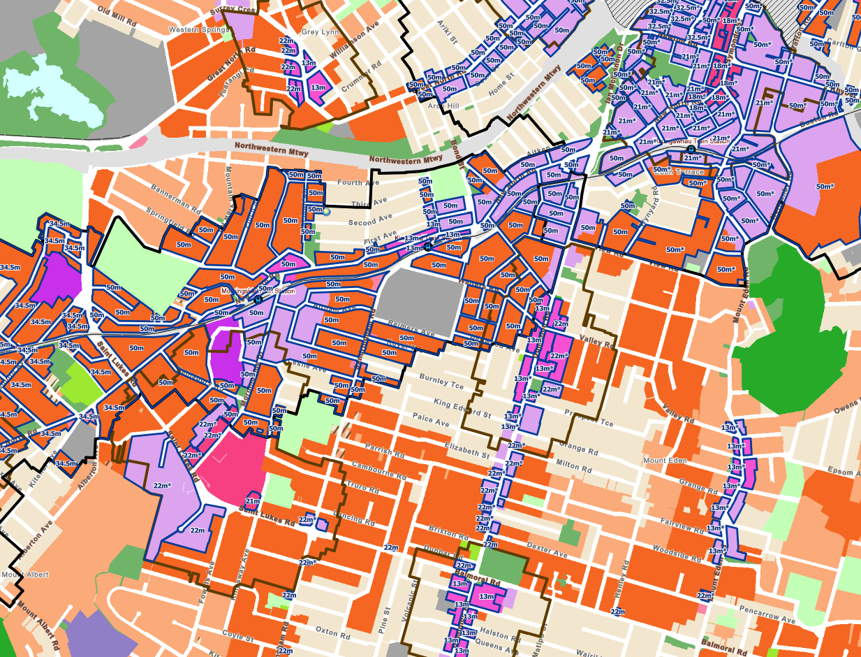
Instead of allowing three-storey development almost everywhere (as PC-78 and the MDRS once proposed), PC-120 focuses growth around rapid-transit stops, key transport corridors, and walkable catchments to town centres. Some areas will see increased heights and new opportunities for mid-density housing, while others may remain largely unchanged.
• Replacement of PC-78 and MDRS
The old one-size-fits-all approach has been removed. PC-120 introduces more nuanced zoning that reflects infrastructure capacity, transport access, and the suitability of different suburbs to support growth.
• New Natural Hazard Overlays
One of the biggest changes is how the Council now assesses natural hazards. New overlays for flood risk, coastal inundation, erosion, instability, and future climate impacts mean some properties may face additional development constraints or require more technical analysis from geotech and civil engineers.
To see exactly how PC-120 may affect your property, visit Auckland Council’s official “Have Your Say” portal. The page includes the full proposal, interactive maps, and all the new overlays introduced through the plan change. It’s the most reliable way to check whether your site sits inside a new growth area, hazard zone, or revised zoning boundary.
You can view it here.
And the new PC120 GIS viewer here.
Why Is PC-120 Happening?
Auckland faces two major issues:
Housing demand far exceeds supply.
The city needs tens of thousands of new homes over the next decade.Not all suburbs are pulling their weight.
Some areas with excellent infrastructure, transport links, and access to jobs still have low-density zoning that restricts development.
The government requires councils to enable greater housing choice. PC-120 is Auckland Council adjusting the rules to comply.
The aim is to create:
more walkable neighbourhoods
more three-storey and terrace-style housing
more density around transport
more opportunities for mixed-use living
This means some properties suddenly become far more developable, while others may see very few changes.
How PC-120 Replaces PC-78 and the Old MDRS Rules
One of the biggest shifts in Auckland’s planning framework is the replacement of the earlier Plan Change 78 (PC-78) and its blanket Medium Density Residential Standards (MDRS). When MDRS was first introduced, it allowed almost every residential property across Auckland to build up to three storeys as of right, regardless of whether the neighbourhood had good transport, infrastructure, or access to services.
It was a one-size-fits-all intensification model, and while it opened the door for more housing, it also created challenges. Some suburbs were never designed to absorb significant growth, and the infrastructure in those areas simply couldn’t keep up.
PC-120 takes a more targeted and intentional approach.
Instead of enabling automatic three-storey development everywhere, it shifts intensification to places where it makes the most sense: areas near rapid transit, town centres, key employment hubs, and walkable, well-serviced neighbourhoods.
In practical terms, this means:
Not every residential site gets three storeys by default anymore
Height and density are now concentrated in high-opportunity areas
Infrastructure constraints and natural hazards play a much stronger role
Special character areas and sensitive environments receive more protection
The outcome is a more strategic version of intensification.
Developers now need to evaluate sites more carefully, and homeowners may find that their property’s development potential has either increased or stayed largely the same depending on where it sits in the network of transport, centres, and hazard overlays.
PC-120 isn’t about removing density, it’s about putting density in the right places.
How Does PC-120 Affect My Property?
The impact depends entirely on where your site sits, and what overlays or zoning controls apply to it.
Areas likely to see the biggest benefit
If your property is near:
a rapid transit stop (train, busway, light rail in future)
a town centre (local, neighbourhood, or metropolitan)
major public transport corridors
…then PC-120 may increase the allowable height or intensity.
Examples of potential outcomes:
A site previously stuck at Mixed Housing Suburban may be shifted into Mixed Housing Urban.
A property near a centre may move from MHU to THAB.
Height limits may increase, allowing more storeys.
Private plan provisions that limited development may be removed.
Areas unlikely to change
PC-120 does not override:
special character areas
ecological areas
volcanic viewshaft protections
flood plains
infrastructure constraints
coastal hazard areas
If your site is heavily constrained, the effects may be minimal.
A New Approach to Natural Hazards
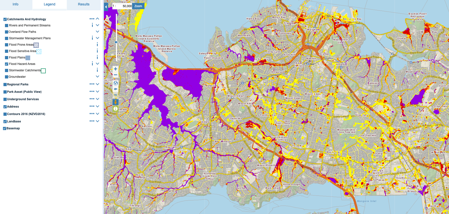
The new ‘Flood Hazard Area’ overlay showing on the Council GIS viewer
One of the most significant shifts within PC-120 is the way Auckland Council now assesses natural hazards. The previous rules focused heavily on flooding, but the updated framework is much broader and far more detailed. New overlays now identify risks relating to coastal inundation, erosion, slope instability, overland flow paths, flooding, and future climate impacts.
For many sites, these overlays won’t change much. For others, they may introduce new requirements for geotechnical investigation, civil engineering design, or additional mitigation measures before a development can proceed. Planners, engineers, and designers are already seeing the effects of these changes, with some projects needing more upfront technical work than before.
Because this topic has deep implications for feasibility, cost, and project timing, we’ll be publishing a dedicated blog post that explains these new hazard rules in detail, including how to check whether they affect your own site, what each overlay means, and how they impact development potential under PC-120.
Tools to Check Whether PC-120 Applies to Your Site
There are a few simple tools you can use:
1. Auckland Council GIS Viewer
This is the most important, as it shows:
zoning
overlays
precincts
special character
walkable catchments
PC-120 layers once activated
Visit: https://maps.aucklandcouncil.govt.nz/
To help, the Auckland Council have even released their own video on how to use the new PC-120 overlays inside the GIS viewer.
2. The PC-120 Planning Maps
Auckland Council publishes a set of maps outlining which zones are affected.
They’re technical, but useful if you need detail for a feasibility. You can find the new PC-120 GIS viewer here.
3. Independent Property Tools (Relab, Homes.co.nz, etc.)
Some third-party tools are beginning to add PC-120 layers or commentary.
What Does PC-120 Mean for Developers?
This is where things get interesting. PC-120 can have a major influence on feasibility and development strategy.
1. Increased Heights and Density
A site that previously only worked for duplexes or small infill housing may now support:
three to five levels
terrace housing
walk-up apartments
more comprehensive multi-unit projects
This can completely reshape the economics of a site.
2. More Flexibility Around Housing Types
Developers can offer:
more units on the same land
a wider range of typologies
better use of infrastructure already in place
This often improves yields and buyer demand.
3. Land Value Impacts
In many cases:
properties with improved zoning may increase in value
low-density properties in high-growth corridors may become more attractive to developers
some older homes become ideal candidates for redevelopment or subdivision
4. The Need for Early Feasibility
Because PC-120 changes controls and permitted heights, your site may have untapped potential that isn’t immediately obvious. Feasibility work (bulk and massing, subdivision options, and high-level costing) becomes essential to assess your options.
Final Thoughts
Plan Change 120 is one of the most significant updates to Auckland’s planning framework in years. It aims to support housing growth, encourage more density in sensible places, and make better use of existing transport and infrastructure.
For some sites, the change could make almost no difference.
For others, it may unlock development potential that wasn’t possible before.
If you want help understanding what PC-120 means for your land, or whether your property could support townhouses, a subdivision, or a more ambitious development, then get in touch. It’s always better to know early.